Biodiversity enhancement plan for an outdoor recreational area in Cratloe
Contents
1.1 Aims of the plan
1.2 Areas chosen for biodiversity enhancement
2 Description and aims for our 3 sites
2.1 Site 1 Raised flowerbed at corner of Church car park and long grassy strip on roadside
Table 1 Threatened butterflies recorded in this area
2.2 Small grassy area beside school
2.3 Site 3 Rocky area to left of the grotto
3 Other areas for biodiversity management highlighted by the trainers’ site visit
3.1 Stone walls beside church and car park
3.2 Approach road soil bank left behind by railway work
Himalayan Honeysuckle (Leycestaria formosa)
Montbretia (Crocosmia x crocosmiiflora)
4.1 Our aims for invasive species control at our sites
6 Tree Nursery for oak saplings
7.1 Planting plan for Site 1 raised flower bed
7.2 Three year enhancement plan
Map 2 NPWS 2010 Ancient and long established woodland inventory
Map 3 Fossit map of habitats for Cratloe area
Fossitt guide to habitats in Ireland 2000
Date: 30th September 2021
Authors: Noreen Ramsay, Ann Breen, Lorraine Power

Abbreviations
Clare CC Clare County Council
CLDC Clare Local Development Company
NBDC National Biodiversity Data Centre
SAC Special Area Conservation
SPA Special Protection Area
Acknowledgements
Everyone who attended the biodiversity training from Cratloe, including those who were not online but were receiving the weekly recordings, would like to extend our thanks to Fran Giaquinto, Linda Gilsenan and Deirdre Morrissey for a wonderful course. It was very inspiring, informative and so well organised. Your generosity in sharing your enthusiasm and knowledge is really appreciated. We are hopeful that it will bear fruit in our community and throughout Clare.
We would like to thank Clare Local Development Company for generously supporting this initiative through LEADER funding which made the training possible.

Cratloe volunteers on the day of the trainers’ site visit
- Introduction
Representatives from Cratloe Community Council who are involved with the Sustainable Cratloe Group, The Tidy Towns Group and the Community Woodland Group attended a training programme hosted by Clare local Development Company. Following a series of webinars and onsite training, which were shared with other members of these groups, a biodiversity enhancement plan has been compiled for 3 specific areas in Cratloe. Two of the sites were chosen because of their potential for enhancement and because they are very visible in an area of high usage near the school and church. The third site was chosen because it represents an area of biodiversity specific to Cratloe.
Cratloe is an area of natural beauty on a hillside above the Shannon estuary in Co Clare. There are records of oak woodland here since medieval times. The remains of the original oak forest is in the Garronnan Wood at the edge of the village and an extensive Coillte forest lies above it. Cratloe woods are a popular place for residents and visitors from Limerick and Shannon. It has a resident red squirrel population along with pine martens, badgers and barn owls. Gorteen Lake has mallards and moorhens nesting and is visited by grey herons and cormorants.
Cratloe is a watershed for the Shannon estuary, which is an SPA and an SAC. The Garronnan Wood and the Woodcock Hill Bog are both NHA. (Appendix Map 1)
Large areas of this forest are designated as ancient or long established woodland by the NPWS woodland survey 2010. (Appendix Map 2)
The extensive Fossit records show areas of oak-birch-holly woodland (WD1), mixed broadleaf / conifer (WD2) mixed conifer woodland (WD3) habitats in among the conifer plantations (WD4). (Appendix Map 3)
The area is spread over 13 townlands with over 650 households. The community surrounds a church, national school, community hall, 2 local shops, 2 pubs, GAA sports hall and grounds and a graveyard. The railway line to Galway runs through it.
1.1 Aims of the plan
- Protect and encourage biodiversity in a planned and measurable way
- Use the site for educational purposes by linking with the national school
- Add to the beauty of this area by enhancing the natural landscaping
- Educate the wider community about management strategies to enhance biodiversity
- Provide a “pause” space to appreciate what we have surrounding us
Strengths
Species rich area
Proximity to old woodland and area of natural beauty
Clean air
Active community groups
Green flag school
Chosen sites are accessible and visible
Challenges
Presence of invasive species at borders of the woodland
Communal green waste not managed
Herbicide spraying in practice to control growth at edges of pathways
High footfall
1.2 Areas chosen for biodiversity enhancement
Site Description
1 Raised flowerbed at corner of Church car park and long grassy strip on roadside
2 Small grassy area beside the school
3 Rocky area to left of grotto

Figure 1 Sketch map showing the location of the 3 chosen sites (not to scale)
2 Description and aims for our 3 sites
In this section we describe our 3 sites and our aims for biodiversity enhancement for each.
2.1 Site 1 Raised flowerbed at corner of Church car park and long grassy strip on roadside.
The aims of the project are:
Description:
At the edge of the church car park there is a large (5m x 4m) raised stone flowerbed, which is now past its best. Plants here include a large horizontal cotoneaster, which has taken over, some shrubs, heathers and self- seeded ash saplings. It is difficult to make sense of visually. Although cotoneaster is loved by birds and bees, its seed is widely dispersed and it can become very invasive. The bed is not overshadowed and is free standing. There is a good depth of soil as it is raised approx. 50 cms.

Image 1 Site 1: Raised flower bed at corner of Church car park
There is a strip of ground (15m long x 1.7m wide) beside the flowerbed and parallel to the footpath. This area, which is in a prominent location, looks unkempt. There are a few young tree saplings which have self seeded, including a holly and hazel but otherwise there is little of interest plant-wise, largely because a weed-suppressing membrane was laid here in the past, topped with some stone and there was no ongoing maintenance of this bed. The rose bushes that were in this strip have been removed.

Image 2 Site 1: Grass strip beside roadside
Our aim for biodiversity enhancement of this site
- To improve the beauty and the visual impact of this area
- To plant pollinator friendly plants, keeping in mind the species that are food plants for the 4 threatened butterflies found in the area. The butterfly records were obtained from the National Biodiversity Data Centre (NBDC) for the national 2 km grid square R46V in which the site lies.
- We have designed a new planting scheme for the raised flower bed with the assistance of Linda Gilsenan, See Section 7.1
Table 1 Threatened butterflies recorded ion this area
Species list R46V Threatened butterflies
Wood White (Leptidea sinapis) Generalist, the adult’s nectar sources include: Bird’s-foot Trefoil (Lotus corniculatus), Bramble (Rubus fruticosus), Bugle (Ajuga reptans), Buttercups (Ranunculus spp.), Greater Stitchwort (Stellaria holostea), Ragged Robin (Lychnis flos-cuculi), Red Clover (Trifolium pratense) and Vetches (Vicia spp.) are also used.
Small Heath (Coenonympha pamphilus) Generalist, adults nectar sources include: Bramble (Rubus fruticosus), Buttercups (Ranunculus spp.), Devil’s-bit Scabious (Succisa pratensis), Fleabane (Pulicaria dysenterica), Greater Stitchwort (Stellaria holostea), Kidney Vetch (Anthyllis vulneraria), Ragwort (Senecio jacobaea), Tormentil (Potentilla erecta) and Yarrow (Achillea millefolium).
Grayling (Hipparchia semele) Generalist, adult nectar sources include: Bird’s-foot Trefoil (Lotus corniculatus), Bramble (Rubus fruticosus), Carline Thistle (Carlina vulgaris), Heather (Calluna vulgaris / Erica spp.), Marjoram (Origanum vulgare), Red Clover (Trifolium pratense), Teasel (Dipsacus fullonum) and Thistles (Cirsium spp. and Carduus spp.).
Dingy Skipper (Erynnis tages) Generalist, adult nectar sources include: Bird’s-foot Trefoil (Lotus corniculatus), Bugle (Ajuga reptans), Buttercups (Ranunculus spp.), Hawkweeds (Hieracium/Hypochoeris), Ragged Robin (Lychnis flos-cuculi) and Vetches (Vicia spp.).
Specialist, the larvae feed exclusively on Bird’s-foot Trefoil (Lotus corniculatus).


Figure 2 Sketch map for Site 1
2.2 Site 2 Small grassy area beside school
Description:
There is a small grassy slope adjacent to the school boundary. It is adjacent to the path that the children use to come out to the field for playtime and also the side gate and path leading up to the Grotto. It is very visible and has a high footfall. However it is surrounded by fencing nearly all the way around which protects it from being walked on. A variety of wildflowers and grasses grow there. It is regularly strimmed and the edge is sprayed with herbicide. A hawthorn grows near the wall. There is a Red Hot Poker plant in the middle of it.
Measuring with a 1 meter square quadrat revealed a paucity of species with vigorous grasses, creeping buttercup and sow thistle dominating

Image 3 Site 2: Grassy area near school
Aim of Biodiversity plan for this area:
- Make a small highly visible area of native wildflower grassland to be enjoyed by the children in the school and those who pass by on the way to the grotto. What we are aiming to achieve here can easily be seen by looking at a grassy area further up the hill by the Grotto road where grasses and wildflowers thrive by not being cut as frequently.
- Increase the number of species growing here to enhance biodiversity and include food plants for the 4 threatened butterfly species in the area. Encourage the Birds’s foot trefoil, red clover, vetches and buttercups that are already growing here as favourite foods of these butterflies and add in yarrow, bugle and devil’s bit scabious.
- Engage the school in the monitoring and management of this area for biodiversity education
- Have a bench nearby which will encourage the children and passersby to pause and look

Image 4 Wildflowers growing near the grotto path

Figure 3 Site 2: sketch map
2.3 Site 3 Rocky area to left of the grotto
Description:
Cratloe has an interesting range of soil types with some pockets of acid soil. This is found on the rocky bank to the left of the grotto. On first glance, this area looks as if it has been overtaken by gorse and bracken, both of which are undesirable in this location. Where the gorse has been cut the cut brush is evident as a thick layer over the highest part of the area.
On closer inspection, the ground dwelling species are very interesting where they are not taken over by the bracken and gorse. We found tormentil, heath milkwort (Polygala serpyllifolia), birds foot trefoil, tutsan (Hypericum androsaemum), cuckoo flower, dog violet, meadow vetchling, catsear, bush vetch, and sweet vernal grass, along with some interesting sedges.
Knapweed was present in the damper, shadier area.
Green waste (mostly woody brush) has been dumped at the woodland edge in this area. This will increase the vigour of undesirable plants such as bracken, brambles, gorse and nettles and it brings the risk of introducing invasive species.

Image 5 Site 3: Rocky area to left of Grotto
Aims for the area:
- Manage it for its native biodiversity
- Manage it to reduce the invasion of Montbretia and the dominance of gorse and bracken.
- Manage the green waste by developing a compost and dead hedge system nearby

Figure 4 Site 3, sketch map
3 Other areas for biodiversity management highlighted by the trainers’ site visit
3.1 Stone walls beside church and car park
There is a beautiful stone wall, which borders the old church grounds. On the church side of the wall we found specialist wall ferns, such as maidenhair spleenwort, wall rue, and rustyback fern, along with some small Hart’s tongue fern, which is an indicator of old habitats

Image 6 Stone wall beside the Church with a rich variety of specialist wall ferns
Notably, the car park stone wall opposite the church (on the car park side) also has some of the fern species but they are very small. It looks as if they have been cut off or power washed, and it will be worthwhile to find out how the wall is maintained and to encourage a greater level of protection for the species that live in or on it.

Image 7 The car park wall where the ferns are very tiny and look as if they have been cut or power washed

Image 8 Ferns on old stone wall beside church
Aims for this area
- Raise awareness about the biodiversity of this wall and to protect it as much as possible.
3.2 Approach road soil bank left behind by railway work
This area is outside the biodiversity plan site, but management advice was given at the time of the site visit.
The area consists of a grassy bank left behind by railway works. Yarrow, ox eye daisy, bush vetch, and birds-foot trefoil are present, and these are all positive indicator species and worth protecting.
Willow and hawthorn have self-seeded at the back of the bank. We will allow these to develop into mature trees with their lovely natural shape. They will not grow tall. In future years, if the willow starts to become invasive we can cut the female plants out to reduce seed dispersal by marking the female trees which have a profusion of fluffy flowers in May and then removing them in Autumn.
3.3 Earth bank at Cratloe woods car park
Several of the earth banks at the car park in Cratloe woods are covered in solitary bee holes and bees can be seen actively using them.
A request has been made to check the identification of the bees.
Janice Fuller, the ecologist for Coillte, has been asked if she can make a visit to see this area and devise a method for its protection and management

Image 9 Earth bank at Cratloe Woods car park

Image 10 Miner bee seen at Cratloe woods earth bank

Image 11 Miner bee nesting holes (red arrows) in the earth bank
4 Invasive species plan
On the site visit it was noted that there are several invasive species in the area, which if left uncontrolled will invade the adjacent woodland.
Rhododendron ponticum
A large Rhododendron ponticum was flowering to the right side of the grotto. This is an Invasive Alien Species of European Union Concern (EU Regulation 1143/2014), and regulated for control under the EC (Birds and Natural Habitats) regulations S.I.477 (2011). This means that it is regarded as a very serious invasive species in Europe and actions must be taken to prevent its spread.
Himalayan Honeysuckle (Leycestaria formosa)
Himalayan honeysuckle has been widely planted as a garden ornamental but it is now becoming a problem throughout Europe. It produces fruit, which are edible to birds and this is the main way it is dispersed. Information about it is documented by NBDC at the following link:
https://species.biodiversityireland.ie/profile.php?taxonId=42928
We have found it growing along and at the edge of the field close to where we plan to make a compost system.
Our plans to control this are:
- Cut it back to ground level repeatedly, and prevent it from flowering. Over time, this will kill it.
- Dig it out in the area where the green waste is to be managed and remove to Mungret green Waste facility.
- Burn or carefully chop up all the shoots that are cut off and compost them separately from the main compost system or rot them in a barrel of water.
-
Montbretia (Crocosmia x crocosmiiflora)
Montbretia is another garden escapee, which is difficult to control once established. It was planted along the border of the grotto walkway, and it is now infesting the edge of the woodland here.
Our plans to control this are:
- Carefully remove shallow rooted corms and rot in a barrel of water
- Include this is in a request for professional removal of invasive species
- Raise awareness among community members in Cratloe and advise everyone not to plant it in their gardens. It produces bulb like corms and these can be easily dispersed.
4.1 Our aims for invasive species control at our sites
- The invasive species at our sites, especially Rhododendron ponticum and montbretia are too difficult to control by community members and there is a risk that we could make the problem worse. So, our plan is to look for funding to appoint a professional contractor to remove these species.
- Coilte will be informed of the problem of Rhododendron ponticum spreading into the woodland. As a statutory body, they are obligated to prevent its dispersal.
- Repeatedly cut back Himalayan honeysuckle and dispose of shoots appropriately (see above).
- We will advise contractors and volunteers who work at our sites to follow the following biosecurity measures:
- Clean all equipment (mowers and strimmers) before coming onto our sites because fragments of invasive species on machinery is one of the main ways by which invasive species are spread.
5 Green waste management
Description
Currently green waste is being dumped at a couple of points around the site as grass is cut or shrubbery cut back. This will increase the vigour of undesirable plants such as bracken, brambles, gorse and nettles and it brings the risk of introducing invasive species. The large piles of cut grass will be producing methane and carbon dioxide and contributing to climate change.
Aim
Develop a managed community composting area to tackle the green waste produced here using a static compost heap system and a dead hedge for the larger brush cuttings. Tidy towns group to manage one area near the edge of the field and the church garden group to manage one area near the grotto.
6 Tree Nursery for oak saplings
Members of the woodland group have noticed oak saplings growing on the road verge by the Garronnan wood. These end up being strimmed by the County Council when they cut back the roadside verges.
Aim
To move these saplings into a temporary tree nursery bed and find homes for them within the community when they are 2-3 years old.

Image 12 Oak sapling on road verge, Wood Road, Cratloe
6.1 Brian Boru Oak sapling
Cratloe has successfully applied for an oak sapling, which Irish Seed Savers have grown from acorns of the ancient Brian Boru oak in Tuamgraney. We have identified a place at the edge of the woodland by the community field away from buildings and roadways where the oak could be allowed to grow to its full potential. We hope that it will become a gathering point for our community connecting us with our own heritage of ancient woodland.
7 Action Plan
Our planting plan for the raised bed (Site 1) is shown in Section 7.1.
Our action plan for our 3 sites for 2021 – 2023 is shown in Section 7.2.
7.1 Planting plan for Site 1 raised flower bed
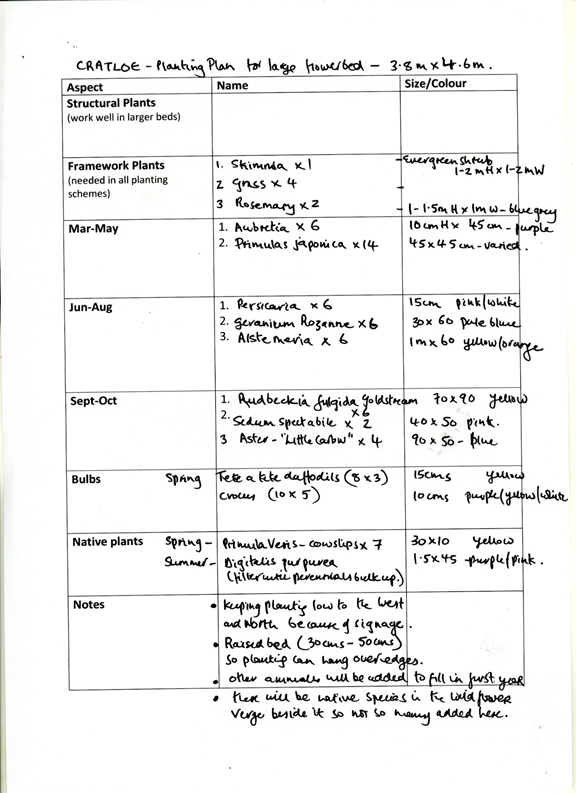

Figure 5 Planting plan for the Site 1 raised bed
Please note that there has been an amendment to this planting plan –
the Alstemeria has been replaced with Achillea millefolium ‘Red Velvet”
7.2 Three year enhancement plan
| Priority/Theme | Action | When |
| Green Waste management Tidy Towns and Church garden group | Identify green waste being produced and a suitable area to set up a community composting area Research Static compost system by visiting Irish Seed Savers Clear an area to set up two organized composting areas – one down by the field and one up by the grotto with the groups working here Improve access for wheelbarrows to these areas Collect fallen leaves to be used as brown material in compost next year Share information with the groups involved about the advantages and methods of composting | July – August September October – December |
| Invasive species Tidy towns Community | Cut back Himalayan honeysuckle before it finishes flowering and dispose of to green amenity waste area in Mungret Submit a request through Clare Local Development for a professional report to prepare an invasive species plan for the whole site and secure funding to engage a recommended professional contractor to carry out the works | September – October September – December |
| 2021 | ||
| The raised flowerbed Site 1 Tidy towns group | Clear out everything that is growing in the raised bed. A local contractor has done this with a small digger. Devise a planting scheme for the area on a 5m x 5m grid. Allow that the height of plants needs to be less than 1.5m because of the low direction sign positioned in the bed. Replace the soil with 15-20cm of good quality screened topsoil to prevent bringing in more weeds. Weed thoroughly, removing all roots of perennials weeds like dandelions and docks. Leave for a couple of weeks to allow weed seeds to germinate; these can then be easily removed before planting. This period of waiting is known as the stale bed technique, it can be repeated a couple of times to allow all the weeds to germinate before we plant up the bed. This will prevent weeds coming up through the new plants. Secure funding for planting from the parish Order perennials and bulbs from Caherhurley Nursery Plant up framework plants, bulbs, perennials Cover with bark mulch to supress weeds | August August – September September – October September October – November |
| The grass strip by the footpath Site 1 Tidy Towns group 2021 | Dig out the membrane, stones and old soil, and refresh with new soil, at the same time that the digger is clearing the flowerbed. Source seed from Design by nature who provide Irish wildflower seeds. Include plants in the wildflower mix which will benefit the 4 local threatened butterfly species – birdsfoot trefoil, devil’s bit scabious, red clover, vetches, buttercups, yarrow. They have recommended their medium height wildflower mix DW02 Sow with a good quality native wildflower seed mix DW02 Plant crocuses and Allium Purple Sensation and Globemaster to make a colourful display. | August – September September September October -November |
| Wildflower area near the school Site 2 Tidy towns and national school | Use a 1 metre Quadrat to measure existing species. Follow the All Ireland Pollinator Plan for reduced mowing. This allows wild flowers which are growing here to flower and set seed. Weed out the sow thistle as it is dominating. Remove the Red hot poker from this area. It is taking over and has no biodiversity value. Remove the willow sapling, which has died after being ring barked by a strimmer. There is a hawthorn tree growing by the wall. Allow this to grow without cutting so that it can develop its lovely natural shape and provide abundant flowers and berries for pollinating insects and birds. Ivy can be removed carefully using a pair of secateurs in the winter months out of the bird nesting season. Meet with Aran Carroll, school green flag coordinator to outline possible school involvement. Discuss with school caretaker to stop use of herbicide near base of Hawthorn and at path edge. Collect seed of some of the wild flowers which are growing nearby – ox-eye daisy, knapweed, vetches, clover red and white, self heal, yellow clover, cats ears and hawks weed. Store over winter for planting in the Spring | June August and September August November October August – September |
| 2021 Rocky area near the grotto Site 3 Church garden group | Use a 1 m2 quadrat and the Key to Indicator Plants to identify the positive and negative indicator species. Discuss management of area with the church garden group Rake off Gorse brush and compost it in the dead hedge area being built near here. Break off bracken fronds and compost Pull Montebretia carefully to make sure all the little corms are removed. Rot corms in a barrel of water in composting area before disposal (Water barrel covered with a wire mesh for safety) Manage an area of composting and a dead hedge (for woody brush) in this area for the green waste produced here. | June September |
| Old Church wall Church garden group | Discuss management with Church garden group Never apply herbicide near it and never power wash. Discrete signage to help identify the different species of fern. | September |
| Miner bee colony Cratloe woods Woodland group | Liaise with Janice Fuller ecologist for Coillte to devise a management plan Woodland group gently weed back bramble and other encroaching weeds from one section of the bank | October September – October |
| Tree nursery bed Woodland group | Mark the saplings by the road by tying pieces of red string around them while in leaf Negotiate a space for the nursery bed in front of the community hall Mark out nursery bed 5m long x 1.2m wide. Turn turf and cover with plastic to prepare weed free ground | July October November November |
| Brian Boru sapling Woodland group | Identify planting place Clear brush and bramble from planting place Tree surgeon to cut back over hanging willow and sycamore to open canopy | September September – October October – November |
| Action plan 2022 | ||
| Priority/Theme | Action | When |
| Green waste management Tidy towns / church garden | Obtain shredded wood and store in compost area to use as brown material for static compost Set up static compost system for composting green and brown waste. Start new static compost heap in March. Start building a 1 metre wide by 1.2 metre high heap from a 50:50 mix of green ( grass and weeds) and brown ( chipped wood ). This will be ready for turning in 4 months. Use branches as posts to start construction of a dead hedge for brown material too big to go in the static compost ( eg gorse clippings) Designate one person to be overall manager of each of the compost areas. Share information and general principles from the course on composting with the community via short articles in the Cratloe newsletter, short videos on community Facebook page, and posts to Sustainable Cratloe Turn static compost heaps and cover with plastic twice a year . Organise a group to do this. Start the new static heap for the next 4 months cycle Review management of waste and adjust compost areas if needed | Jan- Feb March March Jan – June End of June, Early November September |
| Invasive species Community council Tidy towns | Get quotes from a contractor to clear problem species Engage contractor | Spring |
| Raised flower bed Site 1 Tidy towns | Plant rest of perennials. Add annuals for the first year until the perennials bulk up. Put up discrete signage to draw attention to the action | Spring September |
| Wildflower area by the school Site 2 Tidy towns and national school | Sow wildflower seed collected last Summer and plant out as plugs into the area when they are established Monitor and measure the grassy area to see results and plan the mowing regime for following years by using a quadrat to measure and identify wild flower populations in the grassy area. Use The Key to Indicator Plants to identify negative and positive indicator plants. Plan to ask an ecologist to help us do some quadrats in May 2022 with the school children so we can work out what is the best mowing regime and how often to cut Encourage the school to participate in this monitoring and to use the space for one of the national citizen science initiatives. Discuss with Kate O Kelly Cut at times advised by the ecologist. Principles of mowing – Cut high so that the average height of the grass/flowers is about 10 cm. This allows ground dwelling species to survive. Rake off the clippings and dispose of the green waste appropriately to reduce nutrients in the soil and remove thatch, which obstructs flower growth. Involve children in raking off the clippings as it can be enjoyable and educational. Each time the cut grass is removed, the nutrient levels in the soil will become lower and, over time, the grass species here will become less vigorous and this will allow the wild flowers to flourish. Plant Primroses and cowslips in ground beneath Hawthorn tree. Collect wildflower seed for sowing next year | March – April May September June, July, August, September |
| Rocky area beside Grotto Site 3 Church garden group | Use a 1 m2 quadrat and the Key to Indicator Plants to identify the positive and negative indicator species. Strim in mid to late April well before gorse flowers. The risk of strimming in July/Aug is that seed can be dispersed of plants you don’t want, but if the bracken is very vigorous, another strim might be needed just in the areas where it has encroached. Always, the key to success is to cut high ( 10cm or more ) and remove the cut material and remove all green waste from around the area Carefully weed out any Montbretia and rot corms in water | June April June – September |
| Road edge by railway Tidy towns | Dig out brambles or cut them to ground level in the winter months, outside of the bird nesting season. Strim once a year in late September. Keep the cutting level high, above 10 cm and rake off all the cut material and dispose of it appropriately. Willow and hawthorn have self-seeded at the back of the bank. Allow these to develop into mature trees with their lovely natural shape. They will not grow tall. The edge of the bank can be mown April-September to keep it looking tidy at the roadside edge. | October – April September April – September |
| Miner bee colony Cratloe woods Woodland group | Monitor colony with a quadrat counting number of holes of emerging bees Gently remove brambles and other encroaching weeds from selected bank | April – May June – October |
| Tree nursery bed Woodland group | Move saplings from roadside and plant to nursery bed 10-15cm apart with rows 30cm apart before they are strimmed by Council . Move trees from roadside before they are strimmed by council and plant into nursery bed | June July |
| REVIEW PLAN WITH ALL GROUPS INVOLVED IN OCTOBER 2022 | ||
| Action Plan 2023 | ||
| Priority/Theme | Action | When |
| Green waste management Tidy towns and church garden group | Regularly maintain the composting area – topping up supply of brown material as needed, mixing it with grass as it comes in and making the 1 metre wide by 1.2 metre high static compost heaps, which will be ready for turning after 4 months. Remove and use mature compost on beds Turn static compost heaps and cover with plastic twice a year . Organise a group to do this. Start the new static heap for the next 4 months cycle Review how compost area is working and plan development with groups involved Consider ways of reducing green waste – eg cutting certain areas less often or mulch cutting the high use amenity areas | March – November July , November October |
| Invasive species plan Tidy towns | Monitor for the return of invasive species by inspecting the area and remove plants when very young Cut back Himalayan honeysuckle before it finishes flowering and dispose of to green amenity waste area in Mungret | Spring and Autumn August |
| Raised flower bed Site 1 Tidy towns | Ongoing maintenance by Tidy Towns group with weeding and division of perennials every 2- 3 years as they expand. | Spring -Autumn |
| Grass strip by flowerbed Site1 1 Tidy towns | Maintenance ongoing by Tidy Towns – One cut in autumn each year and perhaps some spot weeding if one variety becomes dominant. Cut in early April if necessary | Summer – Autumn |
| Wildflower area by the school Site 2 Tidy towns and national school | Continue reduced cutting regime and removal of cuttings. Might be less often if grasses not as strong Monitor and record plants growing with a quadrat Collect and sow wildflower seeds Source and Install bench nearby where area can be observed | Mid July, end of August, September June Spring |
| Rocky area beside Grotto Site 3 Church garden group | Use a 1 m2 quadrat and the Key to Indicator Plants to identify the positive and negative indicator species. Strim in mid to late April well before gorse flowers. The risk of strimming in July/Aug is that seed can be dispersed of plants you don’t want, but if the bracken is very vigorous, another strim might be needed just in the areas where it has encroached. Always, the key to success is to cut high ( 10cm or more ) and remove the cut material and remove all green waste from around the area Carefully weed out any Montebretia, putting the corms in water to rot. | June April |
| Road edge by railway Tidy towns | In future years, if the willow starts to become invasive you can cut the female plants out to reduce seed dispersal by marking the female trees which have a profusion of fluffy flowers in May and then removing them in Autumn. The edge of the bank can be mown April-September to keep it looking tidy at the roadside edge. Cut back area in September removing cuttings | May October – November April – September |
| Miner bee colony Cratloe woods Woodland group | Cratloe woods Woodland group Monitor colony with a quadrat counting number of holes of emerging bees Gently remove brambles and other encroaching weeds from selected bank | April – May June – September |
| Tree nursery bed Woodland group | Move trees in nursery bed 20-25cm apart with rows 30cm apart. Cut back roots to 10cms when transplanting .At two years old if they are 50-70 cms high move to permanent homes in community. If not move to 40cms apart for final year in the bed Start an Adopt an oak campaign in the community to encourage people to plant an oak if they have space in on their land Continue to collect trees from verge in early Summer and plant into bed , moving them on each November | November September July and November |
| Brian Boru oak sapling Woodland group | Keep smothering vegetation clear Clear overhanging branches | April – September October – November |
| Review plan All groups involved | Review plan and make plan for next 3 years | September – December |
Appendices
Map 1 Special area of conservation (SAC), Special protection area (SPA) and National Heritage area (NHA) maps for Cratloe area

NHA – horizontal blue lines – Garannon oak wood and Woodcock Hill bog
SPA and SAC – orange and crosshatch – Shannon Estuary
Map 2 NPWS 2010 Ancient and long established woodland inventory
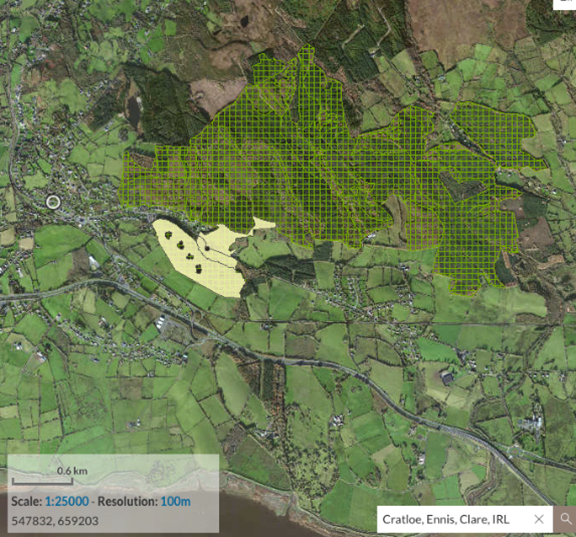
NPWS 2010 ancient and long established woodland – green hatched area
NPWS woodland habitats survey 2010 – yellow area


WD1

WD2

WD3

WD4
Fossitt guide to habitats in Ireland 2000
HIGHLY MODIFIED/NON-NATIVE WOODLAND
WD1 (Mixed) broadleaved woodland This general category includes woodland areas with 75-100% cover of broadleaved trees, and 0-25% cover of conifers.
WD2 Mixed broadleaved/conifer woodland This general category includes woodland areas with mixed stands of broadleaved trees and conifers, where both types have a minimum cover of 25%, and a maximum of 75%.
WD3 (Mixed) conifer woodland This general category includes woodland areas with 75-100% cover of conifers, other than conifer plantation – WD4. The broadleaved component should be less than 25%.
WD4 Conifer plantation This category is used for areas that support dense stands of planted conifers where the broadleaved component is less than 25% and the overriding interest is commercial timber production.
© 2023 Sustainable Cratloe